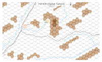
I've been reading Rick Atkinson's excellent An Army At Dawn, an excellent book on Operation Torch and the campaign in Tunisia. In that vein, I figured I'd make a map for PB/PL/AIW or PG use.
I chose to use more of an AIW style for this map (as I will for any more Tunisian maps I will make) as it seemed to represent the terrain well.
Djebel Tahent (Hill 609) is bounded on the South and East sides by cliffs (hence the black lines). The streams were apparently dry or very low as I do not hear them mentioned much in the battle. They probably should be a small movement hinderance to non-foot units, but much more of a hinderance to half-tracked and wheeled vehicles.
The Germans (a composite regiment called Barenthin- composed of convalescent veterans and paratroopers- a tough unit) were set up on 609 and the surrounding hills north of the stream and northwest of Sidi Nsir.
The American 34th Division was entrusted with clearing the area. Needless to say, the battle was tough with many attacks and counter-attacks and lasted from may 27th to April 1, 1943.
This map could also be used for some generic WW2/AIW actions as well.
All in all, a fun map to make, allowing me to extend my mapping symbols to cover some new ground other than Russia.
Any suggestions and all comments as always appreciated.
Edit: North should be about 60 degrees to the west, not straight up (I've corrected this on the map but am not going to repost a new PNG).

4 comments:
Ohh this looks too cool! I wonder do you have scenarios, counters etc for the desert war using Panzerblitz/Panzerleader games at all please? My favourite theatre :) Many thanks cheers!
I kind of make my own counters (I'll do a post on this sometime as I modified the values a little bit and added morale stuff).
But you can find some great stuff right now over at Imaginative stratigist Imaginative Strategist and some great OB stuff at Greg's Panzerblitz Site for starters :D
I have read the book. Good map, but I suggest you reconsider the position of crests on the hills, which seems a little odd.
Thanks :D
I actually used the map from the US Historical Studies map that is in contours.... I might have made a scale problem scanning it in or maybe "interpretation" is wrong.
I'll have to have a look see when I get my comp fully up again....
Post a Comment